David M. Byrne
Well-Known Member
Hello again,
The adventure is continuing in New Zealand. I’m still on the North Island and if being honest am probably spending a little more time up here than planned. But it’s all good. I’ve spent the last week, my 2nd in the country, finally leaving the coast, heading inland and dealing with all things thermal. Thermal, you say? Yep. Read on and find out more via my favourite captures from days 58-63 of ‘Mave On The Move’.
Picture 53, Day 58 – Port Waikato Dunes. May 2nd 2012.
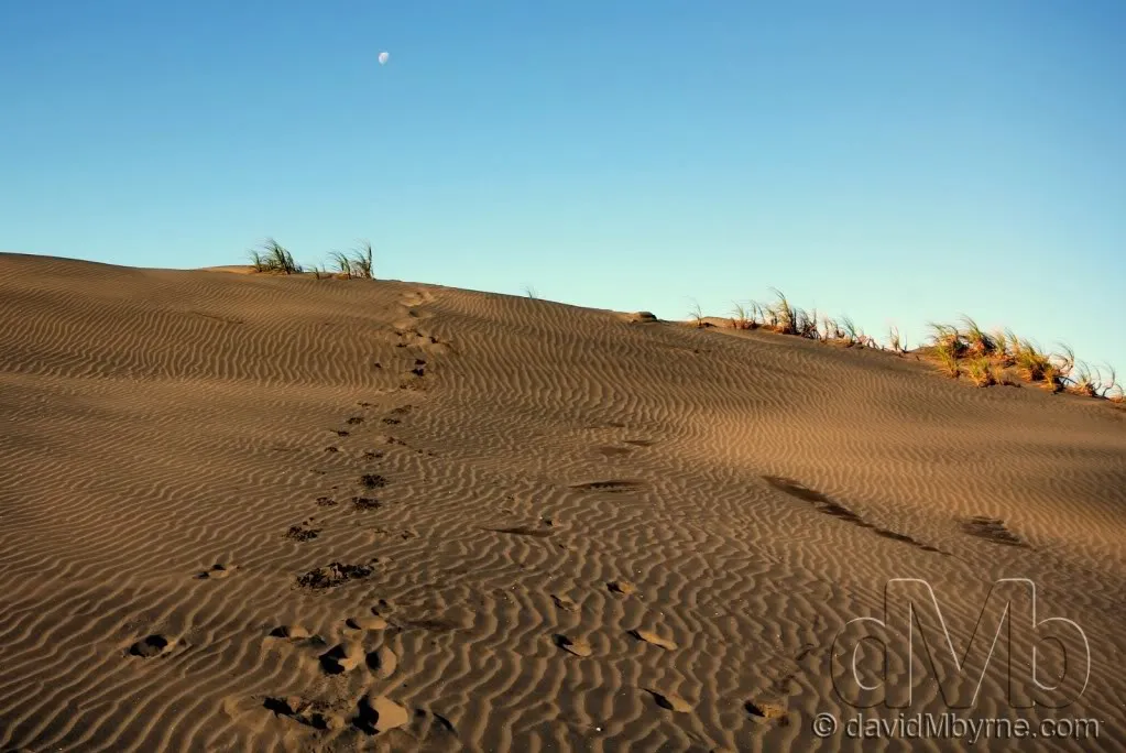
I lied at the end of the last entry when I said no more coastlines, no more beaches. After the tear around Northland a bit of R&R was on the cards so before hitting the thermal centre of the North Island I spent a few days in Port Waikato, a beautiful location on the coast south of Auckland. It was here I captured this picture of footprints on one of Port Waikato’s mountainous, rolling sand dunes.
Picture 54, Day 61 – Kuirau Park, Rotorua. May 5th 2012.
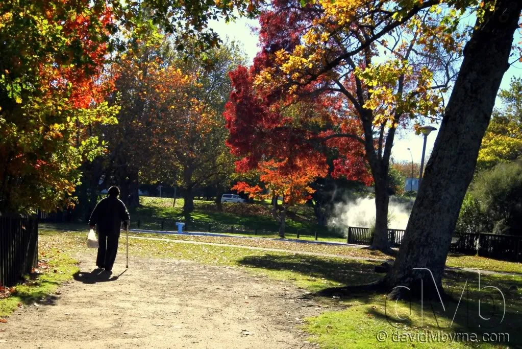
Ok, time to get off the coast. Time to get inland. First stop Rotorua, the tourist hotbed of the North Island & a geothermal wonderland full of geysers, bubbling hot mud pools & clouds of rotten egg-smelling sulphurous gasses. It sits on the Rotorua caledra, one of several active volcanoes in an area known as the Taupo Volcanic Zone. This is an autumnal picture I took in Kuirau Park, a public park/geothermal area that you can wander around for free. Its most recent eruption in late 2003 covered much of the park (including the trees) in mud, drawing crowds of spectators hoping for more displays. It has a crater lake, pools of boiling mud, plenty of huffing steam and mineral baths.
Picture 55, Day 61 – Hells Gate, Rotorua. May 5th 2012.
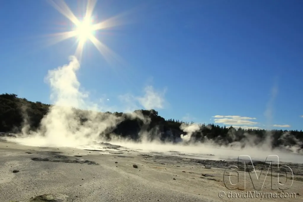
Hell’s Gate is 16km northeast of Rotorua & one of the many $35-entry-fee thermal reserves in the Rotorua vicinity, but the only one owned & operated by a Maori (indigenous New Zealanders) tribe. The Maori name of the 10 hectares reserve is Taku tiki itere nei, meaning ‘my youngest daughter has floated away’, remembering the tragedy of a young girl jumping into a thermal pool. The English name originates from a 1934 visit by George Bernard Shaw. When I visited it was a beautiful day and I like this picture I captured of one of the many steaming thermal pools in the reserve.
Picture 56, Day 61 – Silver Fern. May 5th 2012.
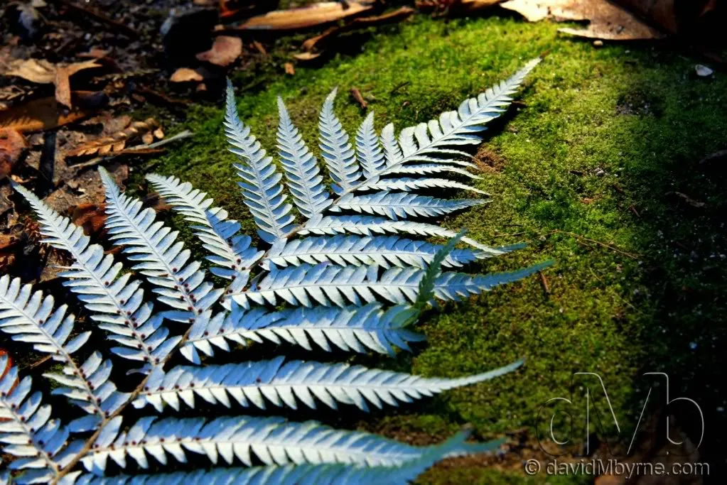
A silver fern resting on the illuminated, mossy forest floor inside the Hell's Gate Geothermal Reserve on the outskirts of Rotorua. The medium-sized tree fern is endemic to New Zealand & is the symbol commonly associated with the country - it appears on the country's coat of arms & many New Zealanders get it tattooed on themselves to show their 'Kiwiness'. I saw this fern lying on the ground about the same time as I saw the light illuminating sections of spongy forest floor, the light having broken through a small gap in the dense forest canopy overhead. I tidied up the fern for presentation (it was fairly battered up having long since fallen to the forest floor), placed it on an illuminated moss mound and took various pictures of it from various angles and with various lenses. This picture, taken with my 24-75mm f/2.8 Tamron lens, was my favourite of the lot.
Picture 57, Day 62 – Whakarewarewa Forest Redwood. May 6th 2012.
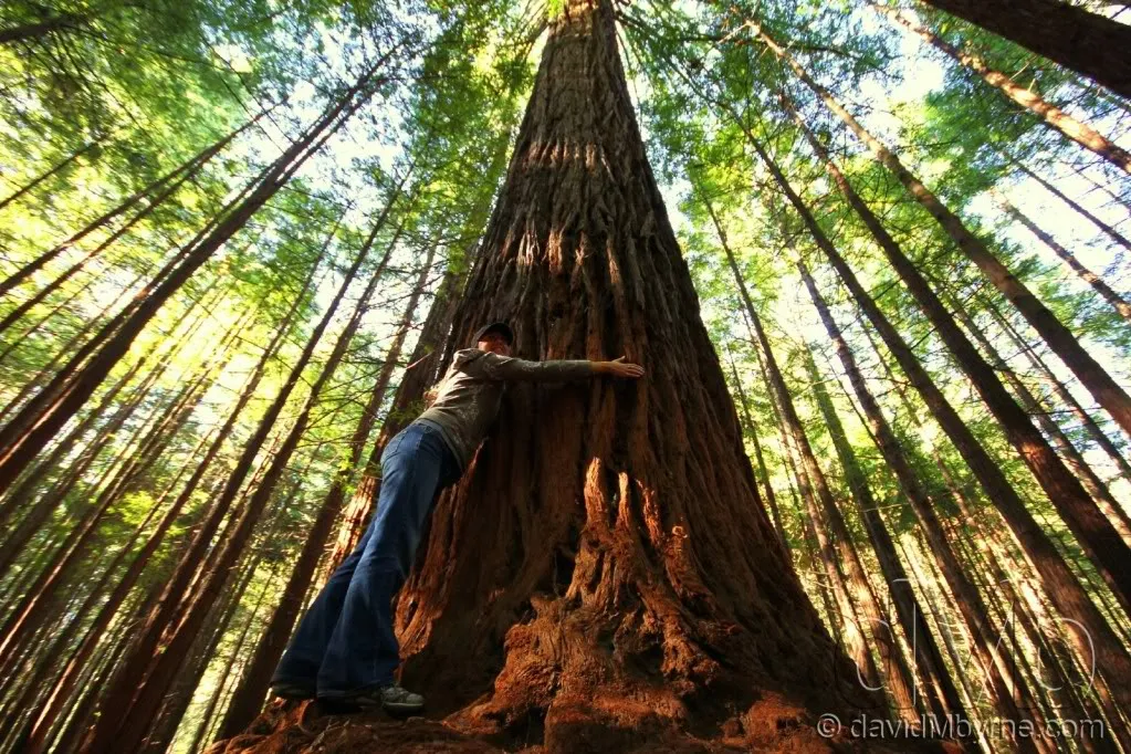
I wasn't expecting to find these bad boys in Whakarewarewa Forest on the outskirts of Rotorua, an exotic forest environment famous for its world-class mountain biking tracks. Of the 170 species of trees found in here it’s the towering Californian Coastal Redwoods that give this place its grandeur. This is a wide-angle picture of a friend of mine, Sheila, hugging one of the parks mighty trees. Trees were only planted in here beginning in 1899 (to see which could be grown most successfully for timber) so at only 112-years-old this is a relatively infantile & thus small Redwood – fully grown Coastal Redwoods can reach over 100 metres in height, 8 metres in diameter & can be 2,000+ years old, marking them as both the largest & oldest trees on earth.
Picture 58, Day 62 – Waikato River. May 6th 2012.
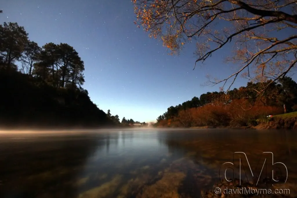
After Rotorua it was on to Taupo, a lake town with its own array of thermal attractions, about 60-90 minutes drive south of Rotorua. I spent my time in Taupo campervaning it (yep, that’s an acceptable phrase) on the shores of the Waikato River, the longest river in New Zealand. It starts its 425km journey here as it drains out of Lake Taupo (see next picture) & winds its way north before flowing into the into the Tasman Sea in Port Waikato, where the 1st picture in this entry, picture 53, was taken. This picture, a 20-second exposure, was taken at 8:30pm (it’s dark out here at this time of year at approximately 6pm). There wasn't a cloud in the sky & it was a bitterly cold night. I wanted to include the moon in the shot I was trying to capture but it was impossible to do because it was just too bright, probably the brightest I ever remember a moon to be. So I settled for this shot instead, with the moon out of frame of to the left.
Picture 59, Day 63 – Hot Ducks, Lake Taupo. May 7nd 2012.
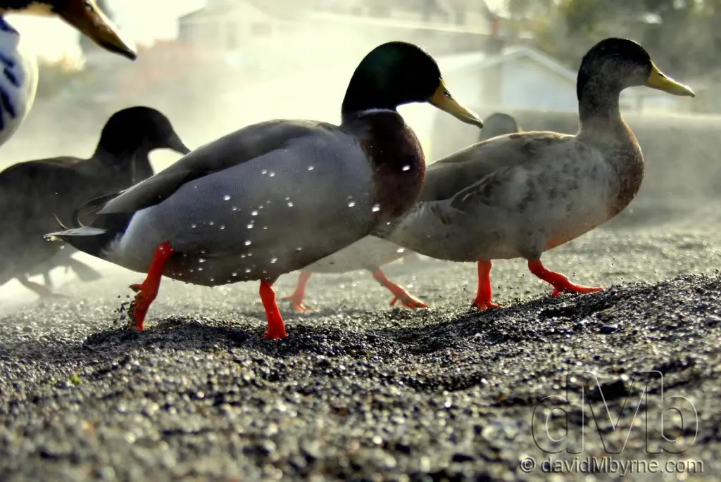
I took this picture of ducks on the march as they emerge from the water of the steamy ‘hot beach’ on the shores of Lake Taupo, a small section of the lake shore heated by an underground thermal rift. It’s probably my favourite capture of the week. Lake Taupo, the biggest lake in New Zealand, is the water-filled crater of a very large volcano. A very, very large volcano & one that has been active for over 300,000 years. The crater, its ‘caldera’, was made by a monumental eruption some 26,500 years ago in what was possibly the biggest volcanic eruption the world has ever seen. Scientists have estimated that since that ‘big bang’ 26,500 years ago the volcano has erupted 28 times, with the most recent eruption being 1,800 years ago. Taupo’s setting is spectacular & it’s hard to believe, standing on the shores of the lake looking out to the peaks of the Tongariro National Park (more on that in next week’s entry), that it was created as the result of such a cataclysmic & destructive event.
What’s Next?
After reading about volcanoes & staring at volcanoes from a distance, it’s time to get up close & personal with them. Tomorrow, day 64 of the trip, we head for the Tongariro National Park. The three active volcanoes it contains dominate the centre of the North Island. We’re hoping - praying even - for good weather for our planed day hike of the Tongariro Crossing, one of the most famed day hikes in the world. Beyond that it’s time to see what the New Zealand capital, Wellington, has to offer. It’s planned to be the last stop on the North Island before crossing the Cook Strait to the South Island.
I hope you enjoyed this latest installment. As with all of my entries I’d love to get feedback (good & bad) on any of the pictures posted here. Finally, don’t forget you can keep up to date with my present whereabouts by visiting the dedicated travel page of my photography blog.
Until next time.
David M
The adventure is continuing in New Zealand. I’m still on the North Island and if being honest am probably spending a little more time up here than planned. But it’s all good. I’ve spent the last week, my 2nd in the country, finally leaving the coast, heading inland and dealing with all things thermal. Thermal, you say? Yep. Read on and find out more via my favourite captures from days 58-63 of ‘Mave On The Move’.
Picture 53, Day 58 – Port Waikato Dunes. May 2nd 2012.
I lied at the end of the last entry when I said no more coastlines, no more beaches. After the tear around Northland a bit of R&R was on the cards so before hitting the thermal centre of the North Island I spent a few days in Port Waikato, a beautiful location on the coast south of Auckland. It was here I captured this picture of footprints on one of Port Waikato’s mountainous, rolling sand dunes.
Picture 54, Day 61 – Kuirau Park, Rotorua. May 5th 2012.
Ok, time to get off the coast. Time to get inland. First stop Rotorua, the tourist hotbed of the North Island & a geothermal wonderland full of geysers, bubbling hot mud pools & clouds of rotten egg-smelling sulphurous gasses. It sits on the Rotorua caledra, one of several active volcanoes in an area known as the Taupo Volcanic Zone. This is an autumnal picture I took in Kuirau Park, a public park/geothermal area that you can wander around for free. Its most recent eruption in late 2003 covered much of the park (including the trees) in mud, drawing crowds of spectators hoping for more displays. It has a crater lake, pools of boiling mud, plenty of huffing steam and mineral baths.
Picture 55, Day 61 – Hells Gate, Rotorua. May 5th 2012.
Hell’s Gate is 16km northeast of Rotorua & one of the many $35-entry-fee thermal reserves in the Rotorua vicinity, but the only one owned & operated by a Maori (indigenous New Zealanders) tribe. The Maori name of the 10 hectares reserve is Taku tiki itere nei, meaning ‘my youngest daughter has floated away’, remembering the tragedy of a young girl jumping into a thermal pool. The English name originates from a 1934 visit by George Bernard Shaw. When I visited it was a beautiful day and I like this picture I captured of one of the many steaming thermal pools in the reserve.
Picture 56, Day 61 – Silver Fern. May 5th 2012.
A silver fern resting on the illuminated, mossy forest floor inside the Hell's Gate Geothermal Reserve on the outskirts of Rotorua. The medium-sized tree fern is endemic to New Zealand & is the symbol commonly associated with the country - it appears on the country's coat of arms & many New Zealanders get it tattooed on themselves to show their 'Kiwiness'. I saw this fern lying on the ground about the same time as I saw the light illuminating sections of spongy forest floor, the light having broken through a small gap in the dense forest canopy overhead. I tidied up the fern for presentation (it was fairly battered up having long since fallen to the forest floor), placed it on an illuminated moss mound and took various pictures of it from various angles and with various lenses. This picture, taken with my 24-75mm f/2.8 Tamron lens, was my favourite of the lot.
Picture 57, Day 62 – Whakarewarewa Forest Redwood. May 6th 2012.
I wasn't expecting to find these bad boys in Whakarewarewa Forest on the outskirts of Rotorua, an exotic forest environment famous for its world-class mountain biking tracks. Of the 170 species of trees found in here it’s the towering Californian Coastal Redwoods that give this place its grandeur. This is a wide-angle picture of a friend of mine, Sheila, hugging one of the parks mighty trees. Trees were only planted in here beginning in 1899 (to see which could be grown most successfully for timber) so at only 112-years-old this is a relatively infantile & thus small Redwood – fully grown Coastal Redwoods can reach over 100 metres in height, 8 metres in diameter & can be 2,000+ years old, marking them as both the largest & oldest trees on earth.
Picture 58, Day 62 – Waikato River. May 6th 2012.
After Rotorua it was on to Taupo, a lake town with its own array of thermal attractions, about 60-90 minutes drive south of Rotorua. I spent my time in Taupo campervaning it (yep, that’s an acceptable phrase) on the shores of the Waikato River, the longest river in New Zealand. It starts its 425km journey here as it drains out of Lake Taupo (see next picture) & winds its way north before flowing into the into the Tasman Sea in Port Waikato, where the 1st picture in this entry, picture 53, was taken. This picture, a 20-second exposure, was taken at 8:30pm (it’s dark out here at this time of year at approximately 6pm). There wasn't a cloud in the sky & it was a bitterly cold night. I wanted to include the moon in the shot I was trying to capture but it was impossible to do because it was just too bright, probably the brightest I ever remember a moon to be. So I settled for this shot instead, with the moon out of frame of to the left.
Picture 59, Day 63 – Hot Ducks, Lake Taupo. May 7nd 2012.
I took this picture of ducks on the march as they emerge from the water of the steamy ‘hot beach’ on the shores of Lake Taupo, a small section of the lake shore heated by an underground thermal rift. It’s probably my favourite capture of the week. Lake Taupo, the biggest lake in New Zealand, is the water-filled crater of a very large volcano. A very, very large volcano & one that has been active for over 300,000 years. The crater, its ‘caldera’, was made by a monumental eruption some 26,500 years ago in what was possibly the biggest volcanic eruption the world has ever seen. Scientists have estimated that since that ‘big bang’ 26,500 years ago the volcano has erupted 28 times, with the most recent eruption being 1,800 years ago. Taupo’s setting is spectacular & it’s hard to believe, standing on the shores of the lake looking out to the peaks of the Tongariro National Park (more on that in next week’s entry), that it was created as the result of such a cataclysmic & destructive event.
What’s Next?
After reading about volcanoes & staring at volcanoes from a distance, it’s time to get up close & personal with them. Tomorrow, day 64 of the trip, we head for the Tongariro National Park. The three active volcanoes it contains dominate the centre of the North Island. We’re hoping - praying even - for good weather for our planed day hike of the Tongariro Crossing, one of the most famed day hikes in the world. Beyond that it’s time to see what the New Zealand capital, Wellington, has to offer. It’s planned to be the last stop on the North Island before crossing the Cook Strait to the South Island.
I hope you enjoyed this latest installment. As with all of my entries I’d love to get feedback (good & bad) on any of the pictures posted here. Finally, don’t forget you can keep up to date with my present whereabouts by visiting the dedicated travel page of my photography blog.
Until next time.
David M
")