David M. Byrne
Well-Known Member
Hello again,
This past week as seen us pass days 78-84 of the trip, days we’ve spent touring the extreme south of New Zealand’s South Island. We’ve spent most of the time driving what is dubbed the Southern Scenic Route, a route of some 600+ kilometres from Queenstown to Dunedin. As the name implies the route is a pretty scenic one with plenty of wildlife, windswept coasts &, as we’ve come to expect in New Zealand, rain. Here are 7 pictures from the last 7 days, pictures 71-77 presented here to the RPF Community to pictorially document my trip.
Picture 71, Day 78 – Wanaka, South Island, New Zealand. May 22nd 2012.
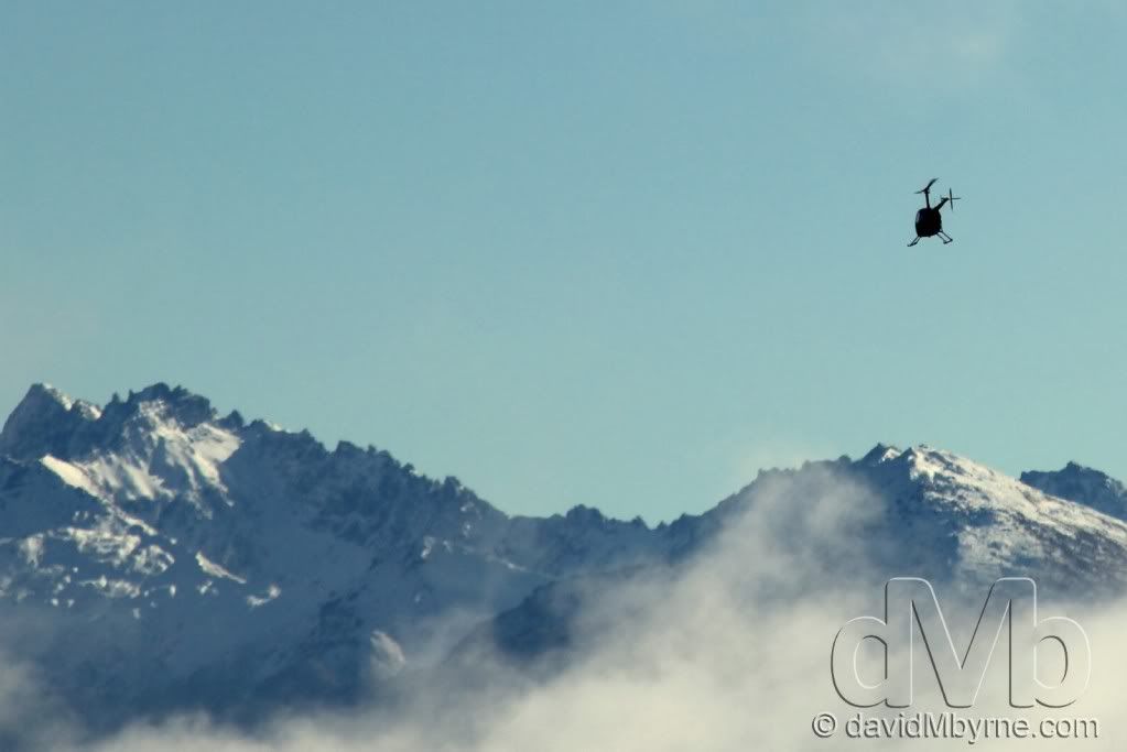
As I said upon closing the last entry we were going to have to pull ourselves away from the beauty of Wanaka and we did so on day 78 of the trip. However, before we hit the road for the 1 hour drive to Queenstown we paid a visit to Wanaka Airport so Mel could throw herself out of a plane strapped to a stranger, all in the name of skydiving. It was here I caught this picture of a helicopter flying towards some of the peaks that help make Wanaka the spectacular place that it is.
Picture 72, Day 79 – Queenstown, South Island, New Zealand. May 23rd 2012.
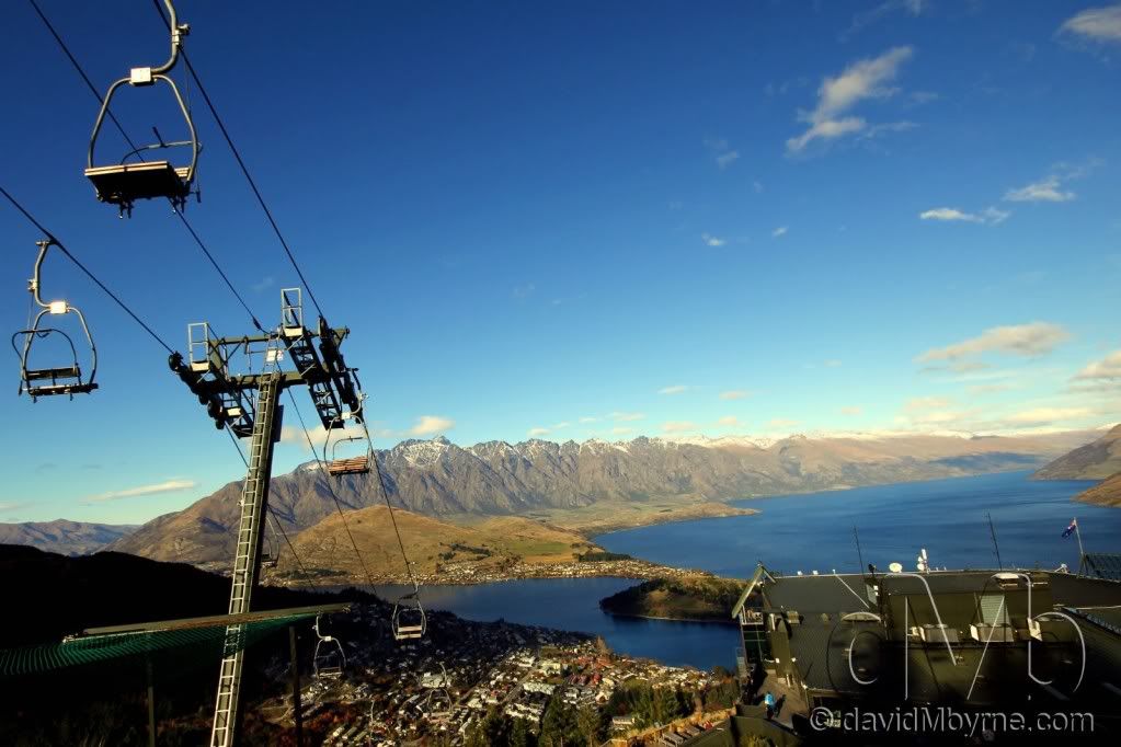
Surrounded by majestic mountains & nestled on the shores of crystal clear Lake Wakatipu, Queenstown has one of the most stunning locations in the world. It’s a location that needs no introduction to those on the traveller circuit - it has a well-earned reputation as the southern hemisphere’s premier adventure destination, thanks in no small part to the opening of the world's first permanent commercial bungee site, the Kawarau Bridge Bungy, just outside Queenstown in 1988 by the entrepreneur AJ Hackett. This is a late afternoon wide-angle picture I took from Bob’s Peak, a steep hill overlooking Queenstown with great views of Lake Wakatipu, New Zealand’s longest lake, & The Remarkabales mountain range, the latter a very popular skiing destination in the winter months of July & August. The Gondola seen here first opened in 1967 & is used to transport passengers from the green Skyline complex seen in the bottom-right of the image to the top of a small luge track behind me. It also extends beyond the Skyline complex down to street level but I found the 40-minute hike up the hill though pine forest a much more rewarding endeavour than paying the $25 round-trip fare, something I did last time I was in Queenstown back in 2003.
Picture 73, Day 82 – Homer Saddle, South Island, New Zealand. May 26th 2012.
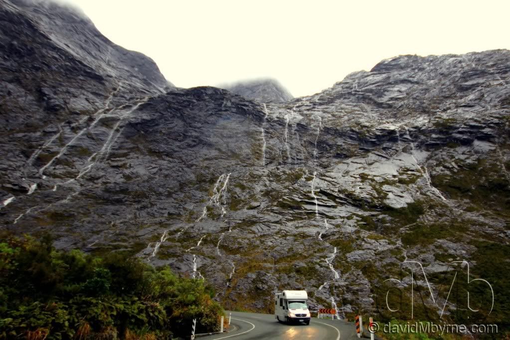
After Queenstown it was time to pay a visit to world renowned Milford Sound. The Sound is a fiord, one of many in Fiordland National Park, but the only one accessible by road. This is a picture I captured of a camper van, not too dissimilar to our own, exiting the west portal of the Homer Tunnel on State Highway 94 en route to Milford Sound. The highway is regarded as one of the most scenic roads in New Zealand, but it's also one of its most dangerous. This section of the road, crossing the Homer Saddle & emerging from the west portal of the Homer Tunnel into the Cleddau Valley, is its highest point & from here the road descends 16 kilometres to Milford Sound. The 1.3 kilometre Homer Tunnel made the trip by car to Milford Sound possible - until it's completion in 1953 the only access to the Sound was by steamer along the south-west coast of by walking the Milford Track. Tourism provided the motivation to build the tunnel but it was the Depression of the 1930's that provided the means. In the winter of 1935 eight men armed with pick axes, shovels & wheelbarrows began clearing rock debris from the base of the Saddle. By summer they had reached solid rock. Machinery was brought in, engineering workshops were constructed & soon hundreds of men were working around the clock. Work ceased during World War II & it wasn't until 1953 before the job was complete & the road opened - apart from slight alterations down the years the tunnel is today as it was when it opened.
Picture 74, Day 83 – Waipapa Point, South Island, New Zealand. May 27th 2012.
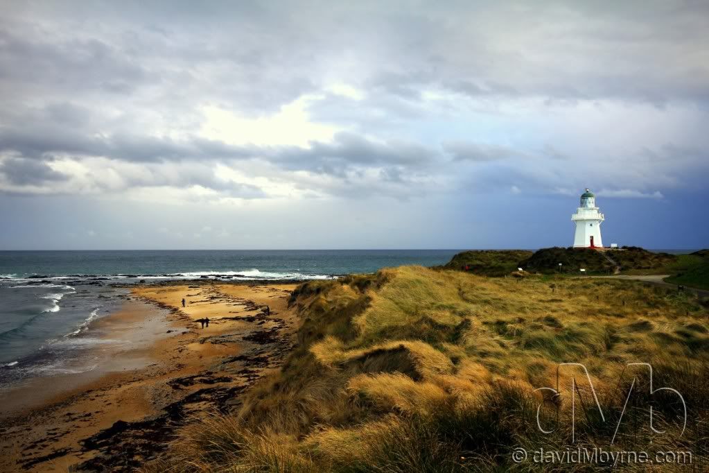
Leaving Fiordland & heading south through Invercargill we spent a few days touring the Catlins, a rugged, sparsely populated area known for its wildlife & scenic coastal landscape. Waipapa Point is a rocky promontory at the extreme south-western end of the Catlins, an exposed location infamous for its frequently wild weather and heavy ocean swells. It's not surprising then to hear that this is the site of New Zealand's worst maritime disaster. On April 29th 1881 the passenger steamer Tararua, en route to Melbourne, Australia, foundered off Waipapa Point with the loss of all but 20 of the 151 people aboard. The lighthouse seen here, Waipapa Point Lighthouse, was built in response to the tragedy - it began operating in 1884 & became fully automated in 1976. The official Catlins pamphlet we had on the area warned us to ‘Come prepared to enjoy dynamic weather conditions.’ It wasn’t wrong – within minutes of us arriving here in nice sunlight the weather had changed, with the ominous-looking blue clouds approaching from the right of the picture putting a dampener on the rest of the days touring.
Picture 75, Day 83 – Fur Seals, Waipapa Point, South Island, New Zealand. May 27th 2012.
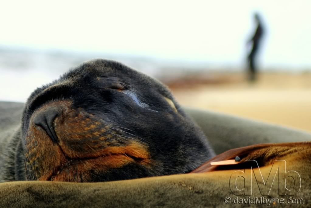
The Catlins area is renowned for its wildlife; penguins, sea lions & Hector’s Dolphins are never too far away. Once haunted to near extinction, the New Zealand Fur Seal can now be found along most rocky coastlines in the south of the country. These particular seals were resting on the sandy beach at Waipapa Point & were totally oblivious to the attention they were garnering from the likes of me and my camera. They were asleep which meant they were the perfect posers.
Picture 76, Day 84 – Catlins Coastline, South Island, New Zealand. May 28th 2012.
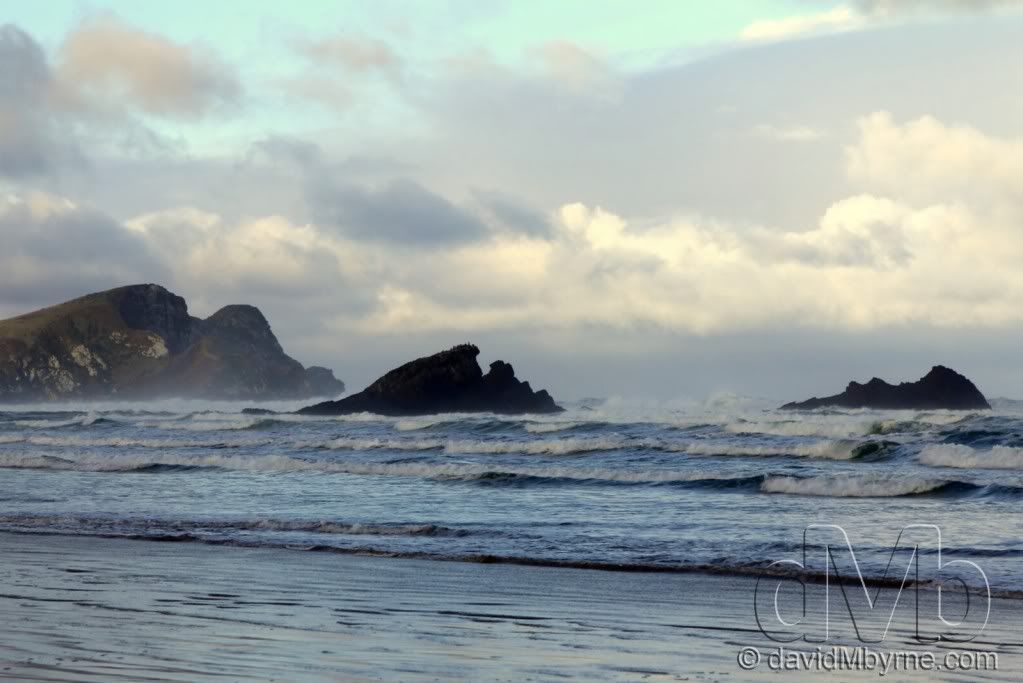
Once the rain dissipated the coastal scenery of The Catlins was/is stunning. This is a picture I captured at Surat Bay, an popular area to see Sea Lions. Unfortunately there were none around when we came calling but we still got to enjoy the isolation of being on a beach while watching the sea pound offshore rock formations.
Picture 77, Day 84 – Nugget Point, South Island, New Zealand. May 28th 2012.
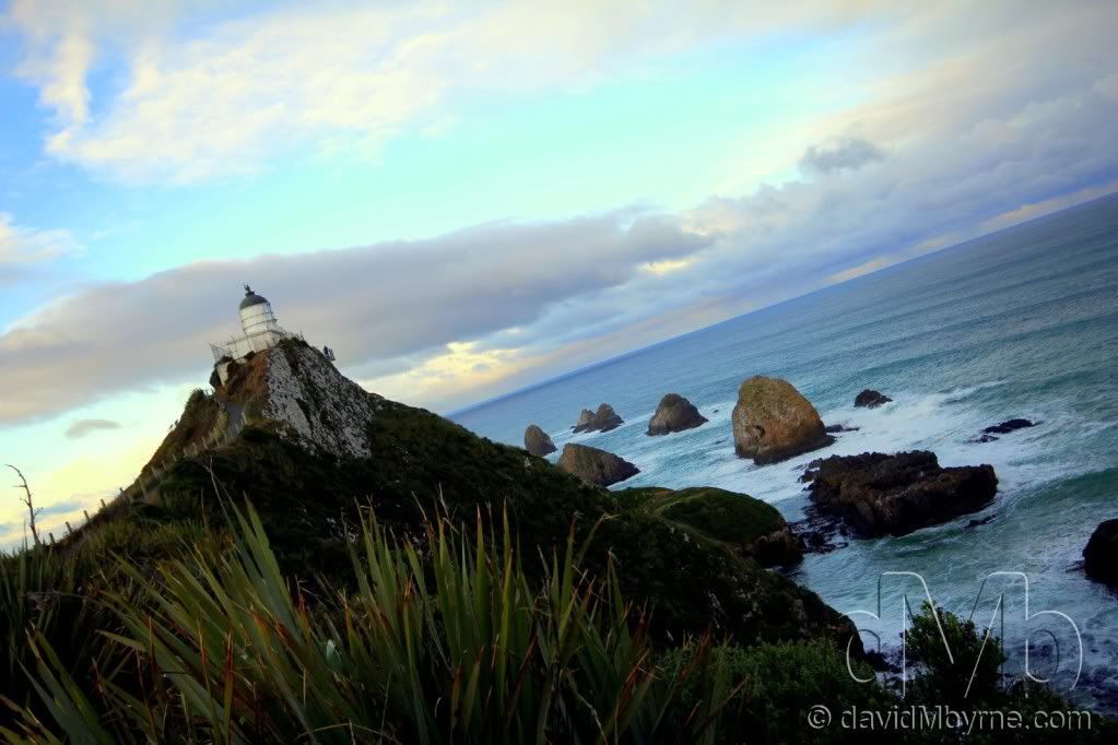
One of the last areas of The Catlins we visited, & again just beating heavy rain to the punch, was Nugget Point, one of the most iconic land forms on the Otago coast. Located at the northern end of the Catlins coast, this steep headland has a lighthouse at its tip, surrounded by rocky islets - The Nuggets. It’s an extraordinarily beautiful & isolated place.
What Next?
We’ve only one week left in the country, one week left with Wilma, our camper van. To say that saddens us is an understatement. But we’re not getting too down in the dumps. Oh no. After all, we still have the two largest cities on the South Island to visit (Dunedin & Christchurch, which we fly out of in a little over a weeks’ time) not to mention the central South Island highlights of Mount Cook National Park & the beautiful Mackenzie Basin.
I hope you enjoyed this latest instalment. Don’t forget you can keep up to date with my present whereabouts by visiting the dedicated travel page of my photography blog.
Until next time.
David M
This past week as seen us pass days 78-84 of the trip, days we’ve spent touring the extreme south of New Zealand’s South Island. We’ve spent most of the time driving what is dubbed the Southern Scenic Route, a route of some 600+ kilometres from Queenstown to Dunedin. As the name implies the route is a pretty scenic one with plenty of wildlife, windswept coasts &, as we’ve come to expect in New Zealand, rain. Here are 7 pictures from the last 7 days, pictures 71-77 presented here to the RPF Community to pictorially document my trip.
Picture 71, Day 78 – Wanaka, South Island, New Zealand. May 22nd 2012.
As I said upon closing the last entry we were going to have to pull ourselves away from the beauty of Wanaka and we did so on day 78 of the trip. However, before we hit the road for the 1 hour drive to Queenstown we paid a visit to Wanaka Airport so Mel could throw herself out of a plane strapped to a stranger, all in the name of skydiving. It was here I caught this picture of a helicopter flying towards some of the peaks that help make Wanaka the spectacular place that it is.
Picture 72, Day 79 – Queenstown, South Island, New Zealand. May 23rd 2012.
Surrounded by majestic mountains & nestled on the shores of crystal clear Lake Wakatipu, Queenstown has one of the most stunning locations in the world. It’s a location that needs no introduction to those on the traveller circuit - it has a well-earned reputation as the southern hemisphere’s premier adventure destination, thanks in no small part to the opening of the world's first permanent commercial bungee site, the Kawarau Bridge Bungy, just outside Queenstown in 1988 by the entrepreneur AJ Hackett. This is a late afternoon wide-angle picture I took from Bob’s Peak, a steep hill overlooking Queenstown with great views of Lake Wakatipu, New Zealand’s longest lake, & The Remarkabales mountain range, the latter a very popular skiing destination in the winter months of July & August. The Gondola seen here first opened in 1967 & is used to transport passengers from the green Skyline complex seen in the bottom-right of the image to the top of a small luge track behind me. It also extends beyond the Skyline complex down to street level but I found the 40-minute hike up the hill though pine forest a much more rewarding endeavour than paying the $25 round-trip fare, something I did last time I was in Queenstown back in 2003.
Picture 73, Day 82 – Homer Saddle, South Island, New Zealand. May 26th 2012.
After Queenstown it was time to pay a visit to world renowned Milford Sound. The Sound is a fiord, one of many in Fiordland National Park, but the only one accessible by road. This is a picture I captured of a camper van, not too dissimilar to our own, exiting the west portal of the Homer Tunnel on State Highway 94 en route to Milford Sound. The highway is regarded as one of the most scenic roads in New Zealand, but it's also one of its most dangerous. This section of the road, crossing the Homer Saddle & emerging from the west portal of the Homer Tunnel into the Cleddau Valley, is its highest point & from here the road descends 16 kilometres to Milford Sound. The 1.3 kilometre Homer Tunnel made the trip by car to Milford Sound possible - until it's completion in 1953 the only access to the Sound was by steamer along the south-west coast of by walking the Milford Track. Tourism provided the motivation to build the tunnel but it was the Depression of the 1930's that provided the means. In the winter of 1935 eight men armed with pick axes, shovels & wheelbarrows began clearing rock debris from the base of the Saddle. By summer they had reached solid rock. Machinery was brought in, engineering workshops were constructed & soon hundreds of men were working around the clock. Work ceased during World War II & it wasn't until 1953 before the job was complete & the road opened - apart from slight alterations down the years the tunnel is today as it was when it opened.
Picture 74, Day 83 – Waipapa Point, South Island, New Zealand. May 27th 2012.
Leaving Fiordland & heading south through Invercargill we spent a few days touring the Catlins, a rugged, sparsely populated area known for its wildlife & scenic coastal landscape. Waipapa Point is a rocky promontory at the extreme south-western end of the Catlins, an exposed location infamous for its frequently wild weather and heavy ocean swells. It's not surprising then to hear that this is the site of New Zealand's worst maritime disaster. On April 29th 1881 the passenger steamer Tararua, en route to Melbourne, Australia, foundered off Waipapa Point with the loss of all but 20 of the 151 people aboard. The lighthouse seen here, Waipapa Point Lighthouse, was built in response to the tragedy - it began operating in 1884 & became fully automated in 1976. The official Catlins pamphlet we had on the area warned us to ‘Come prepared to enjoy dynamic weather conditions.’ It wasn’t wrong – within minutes of us arriving here in nice sunlight the weather had changed, with the ominous-looking blue clouds approaching from the right of the picture putting a dampener on the rest of the days touring.
Picture 75, Day 83 – Fur Seals, Waipapa Point, South Island, New Zealand. May 27th 2012.
The Catlins area is renowned for its wildlife; penguins, sea lions & Hector’s Dolphins are never too far away. Once haunted to near extinction, the New Zealand Fur Seal can now be found along most rocky coastlines in the south of the country. These particular seals were resting on the sandy beach at Waipapa Point & were totally oblivious to the attention they were garnering from the likes of me and my camera. They were asleep which meant they were the perfect posers.
Picture 76, Day 84 – Catlins Coastline, South Island, New Zealand. May 28th 2012.
Once the rain dissipated the coastal scenery of The Catlins was/is stunning. This is a picture I captured at Surat Bay, an popular area to see Sea Lions. Unfortunately there were none around when we came calling but we still got to enjoy the isolation of being on a beach while watching the sea pound offshore rock formations.
Picture 77, Day 84 – Nugget Point, South Island, New Zealand. May 28th 2012.
One of the last areas of The Catlins we visited, & again just beating heavy rain to the punch, was Nugget Point, one of the most iconic land forms on the Otago coast. Located at the northern end of the Catlins coast, this steep headland has a lighthouse at its tip, surrounded by rocky islets - The Nuggets. It’s an extraordinarily beautiful & isolated place.
What Next?
We’ve only one week left in the country, one week left with Wilma, our camper van. To say that saddens us is an understatement. But we’re not getting too down in the dumps. Oh no. After all, we still have the two largest cities on the South Island to visit (Dunedin & Christchurch, which we fly out of in a little over a weeks’ time) not to mention the central South Island highlights of Mount Cook National Park & the beautiful Mackenzie Basin.
I hope you enjoyed this latest instalment. Don’t forget you can keep up to date with my present whereabouts by visiting the dedicated travel page of my photography blog.
Until next time.
David M