David M. Byrne
Well-Known Member
Hello again,
It’s 4pm on May 14th, 2012. It’s day 70 of ‘Mave on The Move’, the end of week 10. As I type I’m sitting on the Interislander vehicle & passenger ferry as it takes me south from Wellington across the Cook Strait, the stretch of water separating the North & South Islands of New Zealand. I hadn't, no offence, planned on doing a RPF entry on this ferry; I envisioned myself out on deck taking pictures of the convoluted maze of the Marlborough Sounds waterway, a crazed geographic omelette of inlets, headlands & peaks that marks the approach to the South Island (photographing the Sounds is primarily the reason I chose a daytime sailing). Alas, the driving rain lashing the window I’m looking through tells me that’s not the best of ideas. And that’s how it has been for the last 3 days of the trip – wet, windy & downright miserable (the weather, not me). It has meant getting any pictures - any good pictures - of Wellington, New Zealand’s capital, has been near on impossible. To make matters worse I was relying on Wellington, relying on it to bulk up this week’s entry. It was a slow week you see so as a result I’m going to put in more pictures of the week’s highlight than I had planned. I hope you don’t mind (and you certainly won’t if, like me, you’re fond of volcanoes).
Picture 60, Day 64 – Whakapapa Ski Field, North Island, New Zealand. May 8th 2012.

After Taupo, where I signed off on the last entry, I headed south a short distance through the volcanic centre of the North Island to spend a few days in the Tongariro National Park. Established in 1887 this was New Zealand’s first national park & is probably its most famous… & definitely its most spectacular. The park is dominated by three peaks, three active volcanoes: Mount Ruapeha, Mount Tongariro & Mount Ngauruhoe. In winter (the northern hemisphere’s summer) it’s a haven for skiers & in summer it’s a haven for hikers, offering some of the world’s best tramps (as in a long walk usually undertaken for exercise or pleasure, not a disreputable vagrant or person who engages freely in promiscuous sex). Whakapapa is one of two ski fields on the slopes of Mt. Ruapehu, the highest (2,797m/9,176ft) and most active of the three volcanoes. It last blew its top in 1995, it threw enough ash & general volcanic detritus into the air to write off the 1996 ski season & it rumbled again as recently as 2007. I like this picture I captured high up on the ski field as clouds rolled in. Needless to say this place is a hive of activity come July with the volcanic rocks seen here covered in snow & the chairlifts in full swing.
Picture 61, Day 65 – Tongariro Alpine Crossing, New Zealand. May 9th 2012.

The Tongariro Alpine Crossing. The week's highlight that I alluded to earlier. Reputedly the best one-day walk in New Zealand, if not the world, the Crossing traverses some of the most spectacular scenery on offer in the Tongariro National Park; at its most memorable points it sees hikers cross an active crater, steaming vents & beautiful coloured lakes. This is a picture I captured of a hiker on the lower part of the crossing, an area of alpine scrub & tussock, with amazing views back to Lake Rotoaria & the southern end of Lake Taupo in the far distance. This picture was taken at 11am, about 3 hours into the 8-hour hike, shortly after the rain that I started out in had stopped & the clouds blocking my view of this scene up to this point had dissipated.
Picture 62, Day 65 – Volcanic Topography, Tongariro Alpine Crossing, New Zealand. May 9th 2012.
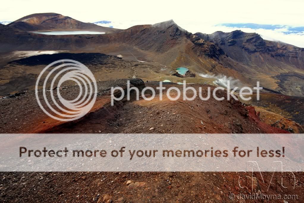
After climbing still further & leaving the alpine scrub & tussock behind, hikers enter a Martian-esque volcanic wonderland by skirting the left of the Blue Lake (top-left of the frame). At this altitude the vegetation disappears altogether & underfoot is volcanic pumice, shale & dust. This picture was taken at the highest point of the Crossing, from the edge of Mt. Tongariro’s Red Crater (1,967m/6,453ft) which last erupted in 1923. In the distance the path I walked to get to this point can be seen (I hope), descending first from the Blue Lake before crossing the uneven central crater of Mt. Tongariro before a scramble up to the edge of the Red Crater, passing steaming vents & the Emerald Lakes, all of which are visible.
Picture 63, Day 65 – Mt. Ngauruhoe, Tongariro National Park, New Zealand. May 9th 2012.

One final picture from the Tongariro Alpine Crossing, this of hikers descending Mt. Tongariro’s Red Crater in full view of the conical Mt. Ngauruhoe (2,287m/7,503ft), the youngest of the parks volcanoes & the only one of the three that actually looks like a volcano (& the reason why it was chosen as fictional Mt. Doom in The Lord of The Rings trilogy). At this stage, about 5 hours into the 8-hour hike, the crossing descends down to a valley hugging the base of Mt. Ngauruhoe (scrambling to its summit is a 3-hour if-you’re-fit-&-or-insane detour off the main crossing route). To get an even better appreciation for the size of Mt. Ngauruhoe see the two walkers on the far side of the Red Crater rim in the distance.
Picture 64, Day 67 – Te Papa, Wellington, North Island, New Zealand. May 12th 2012.
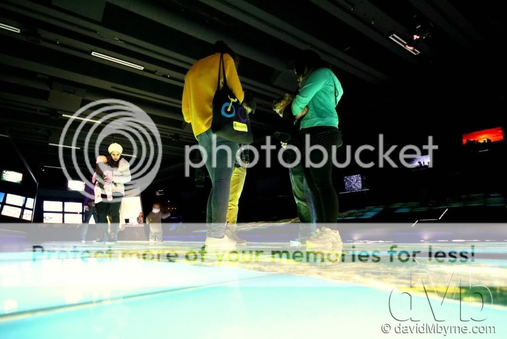
I finished off this week with three wet & windy days in the New Zealand capital of Wellington – it’s not without reason that it’s affectionately called ‘Windy’ Wellington. It was there I captured this picture, about the only picture I captured in Wellington that I liked, of visitors examining a huge illuminated floor map of the country in the Te Papa museum, easily the best museum in the country. Te Papa, the ‘Museum of New Zealand’, is an inspiring, interactive look at New Zealand’s history and culture. Loosely (and affectionately) translated as ‘Our Place’, the museum building dominates the Wellington waterfront and has become a national icon – an innovative celebration of the essence of New Zealand. One could spend a whole day in here or, if a slow reader like me, a few days.
What’s Next?
The South Island. I plan on spending the next week driving down its rugged west coast, which I’ll do as far as Haast before heading inland. I know from being here before that it offers up its fair share of photographic opportunities… more than its fair share. So here’s hoping the weather improves.
I hope you enjoyed this latest installment. Don’t forget you can keep up to date with my present whereabouts by visiting the dedicated travel page of my photography blog.
Until next time.
David M
It’s 4pm on May 14th, 2012. It’s day 70 of ‘Mave on The Move’, the end of week 10. As I type I’m sitting on the Interislander vehicle & passenger ferry as it takes me south from Wellington across the Cook Strait, the stretch of water separating the North & South Islands of New Zealand. I hadn't, no offence, planned on doing a RPF entry on this ferry; I envisioned myself out on deck taking pictures of the convoluted maze of the Marlborough Sounds waterway, a crazed geographic omelette of inlets, headlands & peaks that marks the approach to the South Island (photographing the Sounds is primarily the reason I chose a daytime sailing). Alas, the driving rain lashing the window I’m looking through tells me that’s not the best of ideas. And that’s how it has been for the last 3 days of the trip – wet, windy & downright miserable (the weather, not me). It has meant getting any pictures - any good pictures - of Wellington, New Zealand’s capital, has been near on impossible. To make matters worse I was relying on Wellington, relying on it to bulk up this week’s entry. It was a slow week you see so as a result I’m going to put in more pictures of the week’s highlight than I had planned. I hope you don’t mind (and you certainly won’t if, like me, you’re fond of volcanoes).
Picture 60, Day 64 – Whakapapa Ski Field, North Island, New Zealand. May 8th 2012.
After Taupo, where I signed off on the last entry, I headed south a short distance through the volcanic centre of the North Island to spend a few days in the Tongariro National Park. Established in 1887 this was New Zealand’s first national park & is probably its most famous… & definitely its most spectacular. The park is dominated by three peaks, three active volcanoes: Mount Ruapeha, Mount Tongariro & Mount Ngauruhoe. In winter (the northern hemisphere’s summer) it’s a haven for skiers & in summer it’s a haven for hikers, offering some of the world’s best tramps (as in a long walk usually undertaken for exercise or pleasure, not a disreputable vagrant or person who engages freely in promiscuous sex). Whakapapa is one of two ski fields on the slopes of Mt. Ruapehu, the highest (2,797m/9,176ft) and most active of the three volcanoes. It last blew its top in 1995, it threw enough ash & general volcanic detritus into the air to write off the 1996 ski season & it rumbled again as recently as 2007. I like this picture I captured high up on the ski field as clouds rolled in. Needless to say this place is a hive of activity come July with the volcanic rocks seen here covered in snow & the chairlifts in full swing.
Picture 61, Day 65 – Tongariro Alpine Crossing, New Zealand. May 9th 2012.
The Tongariro Alpine Crossing. The week's highlight that I alluded to earlier. Reputedly the best one-day walk in New Zealand, if not the world, the Crossing traverses some of the most spectacular scenery on offer in the Tongariro National Park; at its most memorable points it sees hikers cross an active crater, steaming vents & beautiful coloured lakes. This is a picture I captured of a hiker on the lower part of the crossing, an area of alpine scrub & tussock, with amazing views back to Lake Rotoaria & the southern end of Lake Taupo in the far distance. This picture was taken at 11am, about 3 hours into the 8-hour hike, shortly after the rain that I started out in had stopped & the clouds blocking my view of this scene up to this point had dissipated.
Picture 62, Day 65 – Volcanic Topography, Tongariro Alpine Crossing, New Zealand. May 9th 2012.
After climbing still further & leaving the alpine scrub & tussock behind, hikers enter a Martian-esque volcanic wonderland by skirting the left of the Blue Lake (top-left of the frame). At this altitude the vegetation disappears altogether & underfoot is volcanic pumice, shale & dust. This picture was taken at the highest point of the Crossing, from the edge of Mt. Tongariro’s Red Crater (1,967m/6,453ft) which last erupted in 1923. In the distance the path I walked to get to this point can be seen (I hope), descending first from the Blue Lake before crossing the uneven central crater of Mt. Tongariro before a scramble up to the edge of the Red Crater, passing steaming vents & the Emerald Lakes, all of which are visible.
Picture 63, Day 65 – Mt. Ngauruhoe, Tongariro National Park, New Zealand. May 9th 2012.
One final picture from the Tongariro Alpine Crossing, this of hikers descending Mt. Tongariro’s Red Crater in full view of the conical Mt. Ngauruhoe (2,287m/7,503ft), the youngest of the parks volcanoes & the only one of the three that actually looks like a volcano (& the reason why it was chosen as fictional Mt. Doom in The Lord of The Rings trilogy). At this stage, about 5 hours into the 8-hour hike, the crossing descends down to a valley hugging the base of Mt. Ngauruhoe (scrambling to its summit is a 3-hour if-you’re-fit-&-or-insane detour off the main crossing route). To get an even better appreciation for the size of Mt. Ngauruhoe see the two walkers on the far side of the Red Crater rim in the distance.
Picture 64, Day 67 – Te Papa, Wellington, North Island, New Zealand. May 12th 2012.
I finished off this week with three wet & windy days in the New Zealand capital of Wellington – it’s not without reason that it’s affectionately called ‘Windy’ Wellington. It was there I captured this picture, about the only picture I captured in Wellington that I liked, of visitors examining a huge illuminated floor map of the country in the Te Papa museum, easily the best museum in the country. Te Papa, the ‘Museum of New Zealand’, is an inspiring, interactive look at New Zealand’s history and culture. Loosely (and affectionately) translated as ‘Our Place’, the museum building dominates the Wellington waterfront and has become a national icon – an innovative celebration of the essence of New Zealand. One could spend a whole day in here or, if a slow reader like me, a few days.
What’s Next?
The South Island. I plan on spending the next week driving down its rugged west coast, which I’ll do as far as Haast before heading inland. I know from being here before that it offers up its fair share of photographic opportunities… more than its fair share. So here’s hoping the weather improves.
I hope you enjoyed this latest installment. Don’t forget you can keep up to date with my present whereabouts by visiting the dedicated travel page of my photography blog.
Until next time.
David M