David M. Byrne
Well-Known Member
Hello again,
It’s the end of day 8 of the New Zealand leg of the trip, day 57 of the trip overall. I’m in a small community town called Dairy Flat, about 60km north of Auckland, the largest city in the country (although not the capital). It has been an eventful 8 days, days I’ve spent in my NZD$35-a-day campervan touring Northland, the rugged finger of land stretching for some 400+kms north of Auckland. Up here it’s all about natural attractions; it’s a sparsely populated area of deserted beaches & coastal scenery. I was never really intending to explore this part of the country, never intending to be still north of Auckland 8 days into the trip. I’ll be heading south of the city for the first time tomorrow but before that, here’s a look at some of my favourite captures from the last 8 days. It’ll come as no surprise to hear that all but one of these pictures are taken by or include water & all but two of them – the first two, pictures 45 & 46 – are taken with my wide-angle lens, a lens that is - & not unexpectantly - getting a lot of use.
Picture 45, Day 53 – Activity on Muriwai Beach, April 27th 2012.
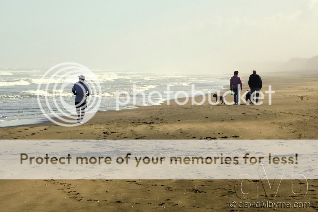
It didn’t take long to get reacquainted with the beauty of this country. After picking up the campervan in Auckland, my first stop was an overnight stay in Muriwai Beach on the Tasman Sea coast west of the city. This stretch of the coast epitomises rugged: bush-shrouded ranges & wild, endless black-sand beaches. Muriwai’s expansive black sand stretches for 50km which goes someway to explain why it seems to disappear off into the distance in this picture.
Picture 46, Day 53 – Perched. Shelly Beach. April 27th 2012.
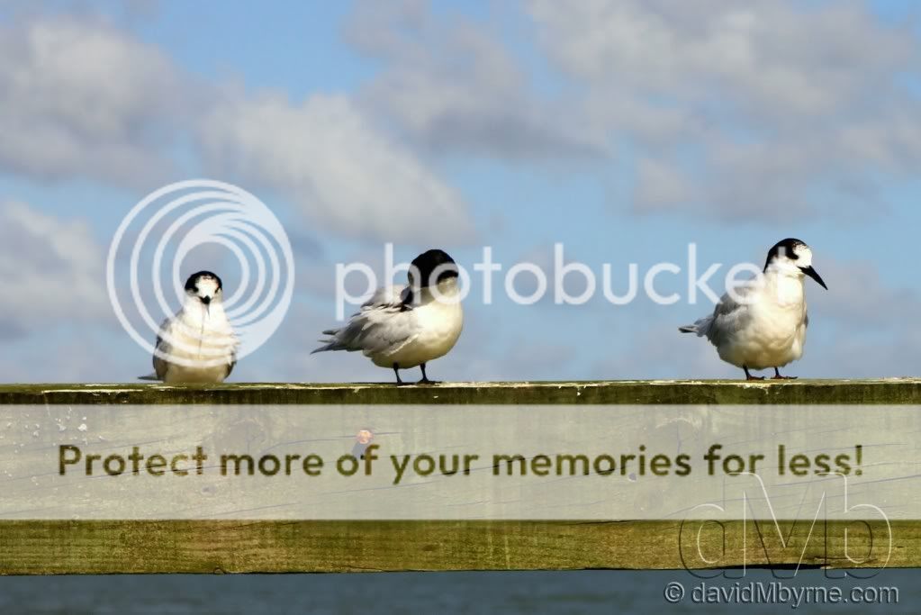
A bit further north from Muriwai Beach is Shelly Beach, just another quaint, unpopulated stretch of sand. This beach sits on Kaipora Harbour, the largest natural harbour in the Southern Hemisphere. On a quick stop for lunch I captured this picture of (I assume) gulls resting on the end of the wooden Shelly Beach pier. It’s a simple picture and it’s the simplicity that I like.
Picture 47, Day 53 – Tawharanui Regional Park. April 27th 2012.
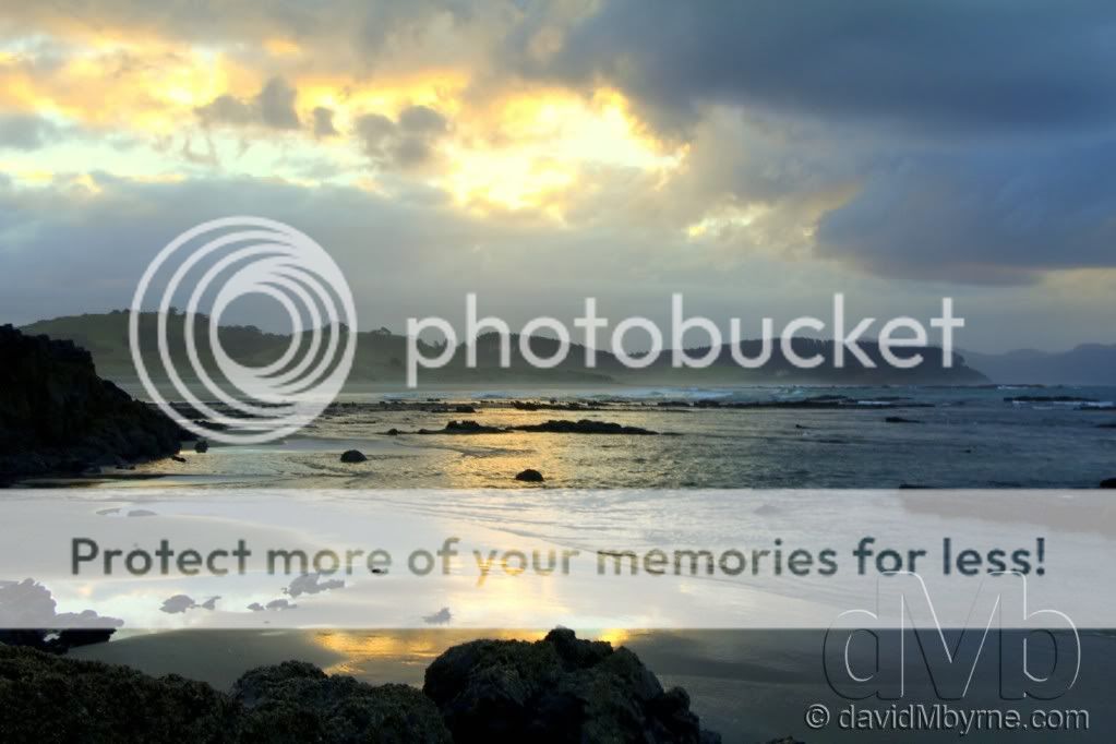
Over on the east coast north of Auckland & things get even more rugged & the partly unsealed road approaching this place, the 588-hectare Tawharanui Regional Park, leaves you in no doubt as to its remoteness. This special place is an open sanctuary for native birds, protected by a pest-proof fence. The campsite here, one of dozens in the country administered by the New Zealand government’s DoC (Department of Conversation), fronts this beach/coast & I spent a few late-afternoon hours down here taking pictures. I could have filled this entry alone with pictures I took during those few hours, with this picture of early sunset being my favourite of the lot.
Picture 48, Day 54 – Surfer. Tawharanui Regional Park. April 28th 2012.
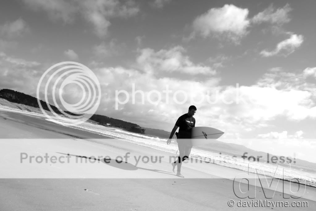
I captured this picture of a surfer on the beach in Tawharanui Regional Park in colour but think it works better as a monochrome image.
Picture 49, Day 56 – Matauri Bay Reflections. April 30th 2012.
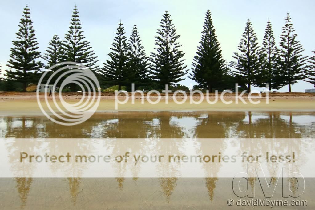
This is an early morning picture I captured from the water’s edge on the beach in Matauri Bay. The trees seen here formed a very picturesque barrier between the beach and the campground I called home for a night. Matauri Bay is located in an area of Northland that Lonely Planet places under the heading ‘the far-flung Far North’. It’s pretty remote up here… & pretty, well, pretty. On top of a headland overlooking the semi-circular bay is a monument to the Rainbow Warrior, the Greenpeace flagship sunk in Auckland harbour in July 1985 as the result of a botched attack by French secret service agents (the ship was preparing to sail to Moruroa Atoll near Tahiti to protest against French nuclear testing). The ship’s final underwater resting place is just offshore and is a popular scuba dive site.
Picture 50, Day 56 – Cape Reinga. April 30th 2012.
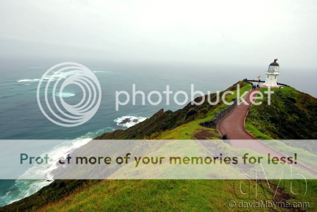
A long drive from Maturi Bay in miserable conditions brought me here to Cape Reinga which sits at the end of the Aupouri Peninsula, a long and thin 108km peninsula of land that forms NZ’s northern extremity. Things get very remote up here & once you get here you’ve no choice but to turn around and head back south. However, as remote as this is, it still isn’t the most northern point of the New Zealand mainland; that honour goes to Surville Cliffs 35kms to the east of here, cliffs that are geographically 3km further north. But the end-of-the-world feeling one gets standing here looking out over the vast expanse of ocean is hard to dilute with petty facts like that (& what’s a mere 3kms amongst remote headlands anyway?). The waves seen here in the top-left of the image are the waters of the Tasman Sea (to the west/left) and Pacific Ocean (to the east/right) meeting & breaking together. It’s an amazing sight. As for the lighthouse itself. The 10 metre tower sits 165 metres above sea level & was the last attended lighthouse to be built in New Zealand; light shone for the first time from here in 1941, replacing the lighthouse on nearby Motuopao Island, it having been built in 1897. It has been fully automated since 1987 & is controlled and monitored by Maritime NZ staff in Wellington. Manned or not, it’s one of the first lights that shipping observes when arriving from the Tasman Sea & northern Pacific, something Abel Tasman wouldn’t have had the benefit of – he was the first European voyager to sail past New Zealand’s north-western tip way back in 1643.
Picture 51, Day 57 – A Boat Moored in Hokianga Harbour, Omapere. May 1st 2012.
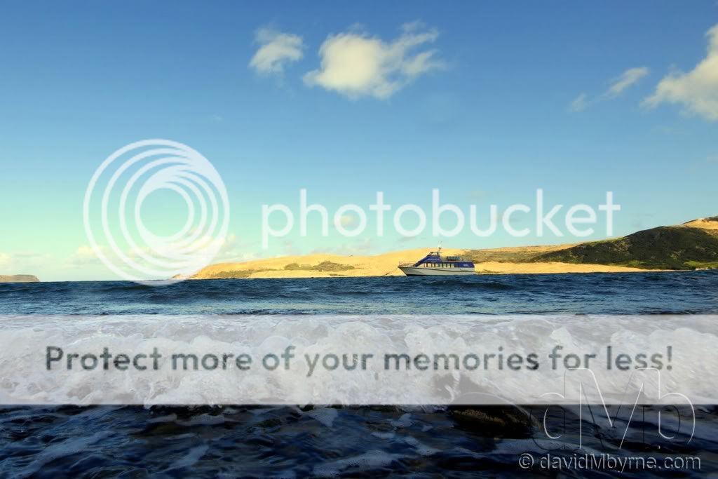
Heading south & back on the west coast of Northland, I took this picture in Hokianga Harbour, a natural harbour that opens out onto the Tasman Sea through the gap in the two headlands seen in the distance. Another simple picture, I like the contrast shown here between the movement in the darker half of the image & the bright stillness of the upper half.
Picture 52, Day 57 – Tane Mahuta. May 1st 2012.
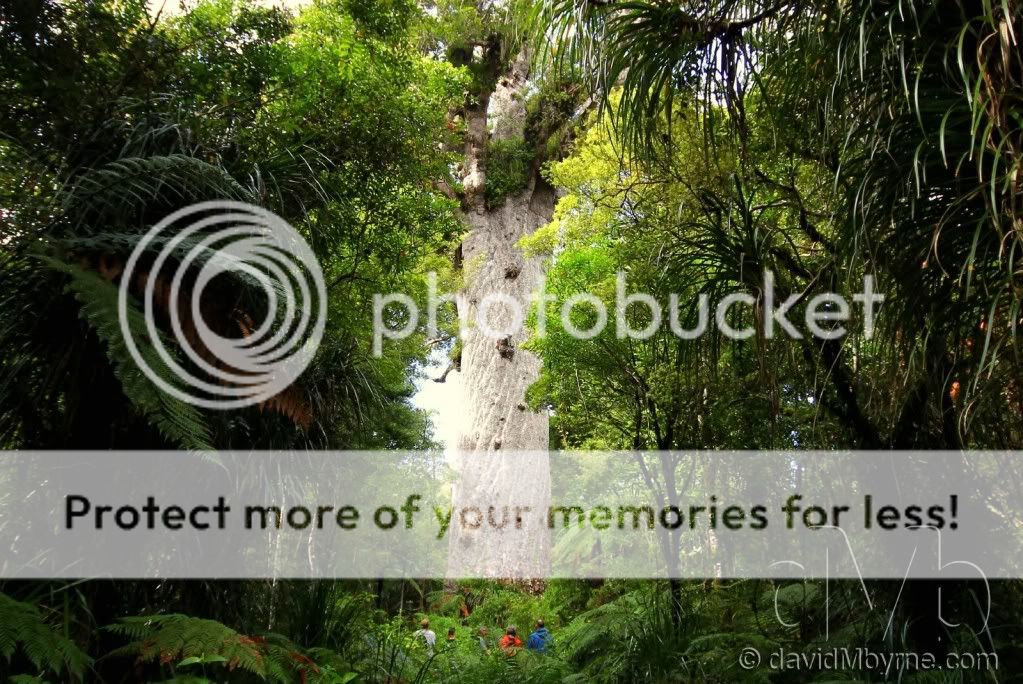
Nope. It’s not a picture of a beach or a coastline & there’s no obvious signs of water. It’s something totally different to end this week’s entry… & totally special. The inscription in front of this tree reads…
‘Tane Mahuta - Lord of the Forest
You are in presence of one of the most ancient of trees.’
This, at 51 metres high & with a 13.8 metre girth and wood mass of 244.5 cubic metres, is Tane Mahuta, the largest kauri tree alive. He’s also one of the oldest - he’s been holding court here for somewhere between 1200 and 2000 years (no one is quite sure exactly how long). He’s found in the Waipoua Kauri Forest, one of the great natural highlights of Northland’s west coast. Kauri forests were once widespread in the northern part of the country but when the Europeans arrived in the mid-19thcentury, they started chopping them down for timber; a lot of the mid-19th century housing in Auckland was made exclusively of kauri. Now only remnants of the once-great forests remain. A fully grown kauri can reach 60m in height and have a trunk 5 to 8 metres in diameter & coming face-to-trunk with a colossal and ancient kauri tree is quite the experience. Its enormous trunk sweeps skywards, straight & bare. No vine or creeper can get a grip on it. The bark has scales that flake off, taking any hangers-on with them. The crowns of the great trees spread outwards and it’s here that the kauri provides homes for vast numbers of perching plants – like gardens in the air. I took quite a few pictures from the base of the tree but this one, taken from a viewing platform some distance away, really shows the immense size of the tree thanks to the inclusion of some observers at its base.
What’s Next?
A substantial change of scenery, that’s what. I’ll be leaving the coast & all its ruggedness & over the next week I’ll be traversing through the thermally active volcanic centre of the North Island. So for the next entry there shouldn’t be any more beaches, any more coastlines… not unless something goes really awry.
New Zealand is, as expected, being a visual feast & what I present here is really only touching the surface. So I hope you’ve seen something here you liked.
Finally, don’t forget you can keep up to date with my present whereabouts by visiting the dedicated travel page of my photography blog. Internet access here isn’t great, to the point that I haven’t been able to tend to my own blog in quite a while & don’t know when I’ll get around to uploading this entry (as I type it’s May 1st). But thankfully I can update, and do update, my present locations on my Travel page thanks to 3G access on the Amazon Kindle.
Until next time.
Regards from New Zealand.
David M
It’s the end of day 8 of the New Zealand leg of the trip, day 57 of the trip overall. I’m in a small community town called Dairy Flat, about 60km north of Auckland, the largest city in the country (although not the capital). It has been an eventful 8 days, days I’ve spent in my NZD$35-a-day campervan touring Northland, the rugged finger of land stretching for some 400+kms north of Auckland. Up here it’s all about natural attractions; it’s a sparsely populated area of deserted beaches & coastal scenery. I was never really intending to explore this part of the country, never intending to be still north of Auckland 8 days into the trip. I’ll be heading south of the city for the first time tomorrow but before that, here’s a look at some of my favourite captures from the last 8 days. It’ll come as no surprise to hear that all but one of these pictures are taken by or include water & all but two of them – the first two, pictures 45 & 46 – are taken with my wide-angle lens, a lens that is - & not unexpectantly - getting a lot of use.
Picture 45, Day 53 – Activity on Muriwai Beach, April 27th 2012.
It didn’t take long to get reacquainted with the beauty of this country. After picking up the campervan in Auckland, my first stop was an overnight stay in Muriwai Beach on the Tasman Sea coast west of the city. This stretch of the coast epitomises rugged: bush-shrouded ranges & wild, endless black-sand beaches. Muriwai’s expansive black sand stretches for 50km which goes someway to explain why it seems to disappear off into the distance in this picture.
Picture 46, Day 53 – Perched. Shelly Beach. April 27th 2012.
A bit further north from Muriwai Beach is Shelly Beach, just another quaint, unpopulated stretch of sand. This beach sits on Kaipora Harbour, the largest natural harbour in the Southern Hemisphere. On a quick stop for lunch I captured this picture of (I assume) gulls resting on the end of the wooden Shelly Beach pier. It’s a simple picture and it’s the simplicity that I like.
Picture 47, Day 53 – Tawharanui Regional Park. April 27th 2012.
Over on the east coast north of Auckland & things get even more rugged & the partly unsealed road approaching this place, the 588-hectare Tawharanui Regional Park, leaves you in no doubt as to its remoteness. This special place is an open sanctuary for native birds, protected by a pest-proof fence. The campsite here, one of dozens in the country administered by the New Zealand government’s DoC (Department of Conversation), fronts this beach/coast & I spent a few late-afternoon hours down here taking pictures. I could have filled this entry alone with pictures I took during those few hours, with this picture of early sunset being my favourite of the lot.
Picture 48, Day 54 – Surfer. Tawharanui Regional Park. April 28th 2012.
I captured this picture of a surfer on the beach in Tawharanui Regional Park in colour but think it works better as a monochrome image.
Picture 49, Day 56 – Matauri Bay Reflections. April 30th 2012.
This is an early morning picture I captured from the water’s edge on the beach in Matauri Bay. The trees seen here formed a very picturesque barrier between the beach and the campground I called home for a night. Matauri Bay is located in an area of Northland that Lonely Planet places under the heading ‘the far-flung Far North’. It’s pretty remote up here… & pretty, well, pretty. On top of a headland overlooking the semi-circular bay is a monument to the Rainbow Warrior, the Greenpeace flagship sunk in Auckland harbour in July 1985 as the result of a botched attack by French secret service agents (the ship was preparing to sail to Moruroa Atoll near Tahiti to protest against French nuclear testing). The ship’s final underwater resting place is just offshore and is a popular scuba dive site.
Picture 50, Day 56 – Cape Reinga. April 30th 2012.
A long drive from Maturi Bay in miserable conditions brought me here to Cape Reinga which sits at the end of the Aupouri Peninsula, a long and thin 108km peninsula of land that forms NZ’s northern extremity. Things get very remote up here & once you get here you’ve no choice but to turn around and head back south. However, as remote as this is, it still isn’t the most northern point of the New Zealand mainland; that honour goes to Surville Cliffs 35kms to the east of here, cliffs that are geographically 3km further north. But the end-of-the-world feeling one gets standing here looking out over the vast expanse of ocean is hard to dilute with petty facts like that (& what’s a mere 3kms amongst remote headlands anyway?). The waves seen here in the top-left of the image are the waters of the Tasman Sea (to the west/left) and Pacific Ocean (to the east/right) meeting & breaking together. It’s an amazing sight. As for the lighthouse itself. The 10 metre tower sits 165 metres above sea level & was the last attended lighthouse to be built in New Zealand; light shone for the first time from here in 1941, replacing the lighthouse on nearby Motuopao Island, it having been built in 1897. It has been fully automated since 1987 & is controlled and monitored by Maritime NZ staff in Wellington. Manned or not, it’s one of the first lights that shipping observes when arriving from the Tasman Sea & northern Pacific, something Abel Tasman wouldn’t have had the benefit of – he was the first European voyager to sail past New Zealand’s north-western tip way back in 1643.
Picture 51, Day 57 – A Boat Moored in Hokianga Harbour, Omapere. May 1st 2012.
Heading south & back on the west coast of Northland, I took this picture in Hokianga Harbour, a natural harbour that opens out onto the Tasman Sea through the gap in the two headlands seen in the distance. Another simple picture, I like the contrast shown here between the movement in the darker half of the image & the bright stillness of the upper half.
Picture 52, Day 57 – Tane Mahuta. May 1st 2012.
Nope. It’s not a picture of a beach or a coastline & there’s no obvious signs of water. It’s something totally different to end this week’s entry… & totally special. The inscription in front of this tree reads…
‘Tane Mahuta - Lord of the Forest
You are in presence of one of the most ancient of trees.’
This, at 51 metres high & with a 13.8 metre girth and wood mass of 244.5 cubic metres, is Tane Mahuta, the largest kauri tree alive. He’s also one of the oldest - he’s been holding court here for somewhere between 1200 and 2000 years (no one is quite sure exactly how long). He’s found in the Waipoua Kauri Forest, one of the great natural highlights of Northland’s west coast. Kauri forests were once widespread in the northern part of the country but when the Europeans arrived in the mid-19thcentury, they started chopping them down for timber; a lot of the mid-19th century housing in Auckland was made exclusively of kauri. Now only remnants of the once-great forests remain. A fully grown kauri can reach 60m in height and have a trunk 5 to 8 metres in diameter & coming face-to-trunk with a colossal and ancient kauri tree is quite the experience. Its enormous trunk sweeps skywards, straight & bare. No vine or creeper can get a grip on it. The bark has scales that flake off, taking any hangers-on with them. The crowns of the great trees spread outwards and it’s here that the kauri provides homes for vast numbers of perching plants – like gardens in the air. I took quite a few pictures from the base of the tree but this one, taken from a viewing platform some distance away, really shows the immense size of the tree thanks to the inclusion of some observers at its base.
What’s Next?
A substantial change of scenery, that’s what. I’ll be leaving the coast & all its ruggedness & over the next week I’ll be traversing through the thermally active volcanic centre of the North Island. So for the next entry there shouldn’t be any more beaches, any more coastlines… not unless something goes really awry.
New Zealand is, as expected, being a visual feast & what I present here is really only touching the surface. So I hope you’ve seen something here you liked.
Finally, don’t forget you can keep up to date with my present whereabouts by visiting the dedicated travel page of my photography blog. Internet access here isn’t great, to the point that I haven’t been able to tend to my own blog in quite a while & don’t know when I’ll get around to uploading this entry (as I type it’s May 1st). But thankfully I can update, and do update, my present locations on my Travel page thanks to 3G access on the Amazon Kindle.
Until next time.
Regards from New Zealand.
David M
")